For first-time users, however, the system can initially look complicated. Six color-coded lines cross the city, several stations provide interchange opportunities, and the metro works alongside Riyadh’s bus network.
This guide explains how to use the Riyadh Metro, how the six lines work, which stations matter to visitors, how Darb cards fit into the system, how to connect with the airport and what to know before your first journey.
What Is the Riyadh Metro?
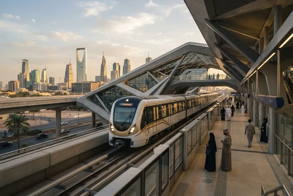
The Riyadh Metro is the rail component of the King Abdulaziz Public Transport Project. The network consists of six automated metro lines integrated with Riyadh’s wider bus transportation system.
The Royal Commission for Riyadh City describes the metro as an automated system forming part of an integrated public transportation network that also includes bus rapid transit and community bus services. Current RCRC open-data records continue to maintain station information by metro line for 2026.
The metro network covers approximately 176 kilometers and was designed to provide connections across the capital rather than operate as a single north-south or east-west route.
For visitors, that means the most useful way to understand the system is by learning the six lines, identifying interchange stations and then choosing the route that gets you closest to your destination.
How Many Riyadh Metro Lines Are There?
There are six Riyadh Metro lines. Each has its own color and general corridor through the city.
- Blue Line: Olaya–Bathah corridor
- Red Line: King Abdullah Road corridor
- Orange Line: Madinah Al Munawarah Road–Prince Saad bin Abdulrahman Al Awal Road corridor
- Yellow Line: King Abdulaziz Road and airport corridor
- Green Line: King Abdulaziz Road–King Abdullah Road corridor
- Purple Line: Abdul Rahman Bin Ouf Road–Sheikh Hassan Bin Hussein Bin Ali Road corridor
The official Riyadh Metro map shows all six lines together with interchange stations, airport stations, park-and-ride facilities and connections with the wider public transport network.
Riyadh Metro Lines Explained
Blue Line
The Blue Line is one of the most important corridors for central Riyadh. It runs through major parts of the city and connects areas around Olaya with central destinations and the southern part of the capital.
For visitors, the Blue Line can be useful when traveling toward central Riyadh and connecting with other lines at interchange stations.
Red Line
The Red Line follows the King Abdullah Road corridor. It provides an important east-west connection across Riyadh and intersects with other metro services.
Its position makes it useful for travelers staying or working near King Abdullah Road and for passengers transferring to other parts of the network.
Orange Line
The Orange Line runs along a major east-west corridor from the western side of Riyadh through central areas toward the east.
It connects with several important districts and provides interchange opportunities with other metro services.
Yellow Line
The Yellow Line is particularly important for air travelers because it serves the King Khalid International Airport corridor.
The official Riyadh Metro map identifies airport stations including Terminal 1–2, Terminal 3–4 and Terminal 5 on the airport section of the network.
If you are arriving in Riyadh by air, this is the line to examine first when planning a metro-based journey into the city.
Green Line
The Green Line serves the King Abdullah Road area and connects with other lines within the wider network.
It is useful for passengers traveling between several central and eastern areas of Riyadh and for journeys requiring an interchange.
Purple Line
The Purple Line runs through a series of eastern and southeastern corridors and connects with the wider metro network at key interchange points.
Its importance becomes clearer when planning a journey across multiple districts rather than traveling only within central Riyadh.
Riyadh Metro Stations You Should Know
With a large number of stations across six lines, visitors do not need to memorize the entire network. It is more useful to recognize major destinations and interchange points.
The official network map identifies important locations including King Abdullah Financial District (KAFD), King Saud University, National Museum, Qasr Al Hokm, King Fahad Library, Ministry of Interior, Al Malaz, Granada, King Salman Park and King Khalid International Airport.
KAFD Station
The King Abdullah Financial District station is one of the most recognizable stations in the Riyadh network. The station is associated with the KAFD business district and is also notable for its striking architecture.
Riyadh Art has incorporated permanent public artworks into several metro stations, including KAFD, making some stations destinations in their own right.
Qasr Al Hokm Station
Qasr Al Hokm is an important central Riyadh station serving an area associated with the historic and administrative heart of the city.
The surrounding area can be useful for visitors interested in exploring central Riyadh beyond the city’s newer business districts.
National Museum Station
The National Museum station provides metro access to the area around the National Museum and surrounding central Riyadh attractions.
It is one of the more useful stations for travelers building a cultural itinerary around central Riyadh.
King Saud University Station
King Saud University is served by the metro network and is an important landmark on the western-central side of Riyadh.
King Salman Park
The metro map also identifies King Salman Park within the wider network, making public transportation increasingly relevant to visitors exploring the capital’s major urban projects.
How Riyadh Metro Interchange Stations Work
An interchange station allows passengers to move from one metro line to another without leaving the public transport network.
This is particularly important because you may not have a direct train from your starting station to your destination.
For example, a journey might involve:
- Boarding your first metro line.
- Traveling to an interchange station.
- Following the signs for the connecting line.
- Boarding the second line.
- Continuing to your destination station.
The official network map marks interchange stations separately, making them easier to identify when planning a route.
Before starting your trip, check the complete route rather than assuming that the nearest station to your destination is on the same line as your starting point.
How to Read the Riyadh Metro Map
The Riyadh Metro map is color-coded, which makes route planning considerably easier.
First, find your starting station. Then locate your destination. Next, identify the color of the line serving each station and determine whether you need to change lines.
The official map also identifies:
- Metro stations
- Interchange stations
- Airport terminals
- Park-and-ride facilities
- Bus rapid transit connections
- Public transportation centers
- High-speed rail connections
The latest official network map is therefore more useful than relying on an old tourist map or screenshot shared on social media.
What Is a Darb Card?
The Darb card is part of Riyadh’s public transport ticketing system and is used for accessing public transportation services.
For visitors planning to use the metro and buses during their stay, understanding the Darb system is important because Riyadh’s public transport network is designed as an integrated system rather than a metro-only service.
The broader public transport project was designed to integrate metro services with bus and feeder routes, allowing passengers to transfer between different forms of public transportation.
Where Can You Get a Darb Card?
Passengers should use the official ticketing facilities available within the Riyadh public transport system to purchase or manage their travel card.
Because ticketing products, prices and sales channels can change, check the current official public transport information before traveling rather than relying on an older fare guide.
Keep your card accessible throughout your journey and follow the instructions displayed at stations and ticketing machines.
How Much Does Riyadh Metro Cost?
Metro fares and ticket products can change as the public transport system evolves. Travelers should therefore confirm the current fare shown through official Riyadh public transport channels before purchasing a ticket or loading a Darb card.
Do not assume that an older online fare table is still current in 2026.
This is especially important for visitors because Riyadh’s integrated transportation system includes different products and services, and the applicable fare can depend on the ticket or pass selected.
How to Ride the Riyadh Metro for the First Time
Your first metro trip can be straightforward if you prepare your route in advance.
1. Find Your Starting Station
Locate the metro station closest to your hotel, home, workplace or current destination.
2. Identify Your Line
Check the color and number of the line serving your station.
3. Check Whether You Need to Transfer
If your destination is on another line, identify the interchange station before boarding.
4. Enter the Station
Follow the signs and use your valid transport payment method as directed.
5. Follow Platform Signs
Check the train’s direction and destination information before boarding.
6. Watch the Station Displays
Electronic displays and announcements help passengers identify upcoming stops and train information.
7. Exit at Your Station
Once you arrive, follow the signs toward the appropriate exit or connecting bus service.
For your first trip, allow additional time so you can understand the station layout without rushing.
Riyadh Metro Airport Transfer: How to Get From King Khalid Airport to Riyadh
One of the most useful features for international visitors is the connection between the Riyadh Metro network and King Khalid International Airport.
The official network map shows metro stations serving the airport terminals, including Terminal 1–2, Terminal 3–4 and Terminal 5.
This makes the metro a potentially useful option for travelers who want to continue into Riyadh without immediately relying on a private car or taxi.
From Airport Terminals to the Metro
After collecting your luggage and completing airport arrival procedures, follow the airport’s public transportation signs toward the metro station serving your terminal.
Check the line direction before boarding and confirm where you need to transfer if your final destination is not directly served by the airport corridor.
Airport to Central Riyadh
Passengers traveling toward central Riyadh can use the airport metro connection and transfer to another line where necessary.
The best route depends on your final destination. For example, a passenger heading toward KAFD, Olaya, the National Museum area or another district may need a different interchange.
Riyadh Metro and Riyadh Bus Connections
The metro does not operate in isolation.
Riyadh’s public transport program combines six metro lines with a large bus network, including bus rapid transit and community services. The official RCRC documentation describes the system as an integrated public transportation network designed to connect metro stations with bus services.
This means that your final destination may be closer to a bus stop than a metro station.
For some journeys, the most efficient route may therefore be:
Metro → interchange → bus → destination.
When planning a trip, consider the entire public transport network instead of searching only for the nearest metro station.
Park-and-Ride at Riyadh Metro Stations
Drivers do not necessarily need to take their cars into central Riyadh.
The official network map identifies park-and-ride facilities at selected locations, allowing passengers to leave their vehicles and continue their journey by public transportation.
This can be useful for residents traveling from outer districts toward central business or cultural areas.
Check the current availability and operating arrangements for the specific park-and-ride facility you intend to use before starting your journey.
Riyadh Metro for Tourists
For tourists, the metro is particularly useful when visiting several parts of Riyadh during the same trip.
Instead of arranging a separate car journey for every destination, visitors can combine metro travel with walking, taxis or buses for the final part of a journey.
A visitor itinerary might include:
- King Khalid International Airport
- KAFD
- National Museum
- Qasr Al Hokm
- King Salman Park
- Olaya
- Central Riyadh
The exact route will depend on the opening status and service arrangements at the time of travel, but these destinations are represented on the official Riyadh transport network.
Riyadh Metro and KAFD
King Abdullah Financial District is one of the most recognizable destinations connected to the Riyadh Metro.
The KAFD station is notable not only for its transport role but also for its architecture and public-art installations. Riyadh Art identifies permanent works at the station, including works by Alexander Calder and Robert Indiana.
This makes a metro journey to KAFD potentially part of the sightseeing experience rather than simply a method of transportation.
Riyadh Metro and Culture
The metro system has also become part of Riyadh’s cultural landscape.
Riyadh Art has integrated public artworks into metro stations and surrounding transportation spaces. The program includes permanent artworks intended to bring art into everyday movement around the city.
At stations such as KAFD, Qasr Al Hokm and Olaya, visitors can encounter works that connect contemporary public art with different parts of Riyadh’s urban identity.
For travelers interested in Saudi culture, this is one of the less obvious reasons to explore the metro rather than treating it purely as transportation.
Accessibility on Riyadh Metro
Accessibility was incorporated into the design of the Riyadh public transport system, including provisions for passengers with mobility needs.
The broader Riyadh Metro project documentation describes trains designed to accommodate passengers with mobility impairments and stations built as part of an integrated public transportation system.
Passengers requiring specific assistance should check current station facilities and speak with staff when planning their journey.
Tips for Riding Riyadh Metro
- Check your route before entering the station.
- Remember the color of your metro line.
- Identify your interchange station in advance.
- Keep your Darb card or approved payment method accessible.
- Allow extra time during your first journey.
- Check the final station exit because large stations can have multiple exits.
- Use the metro together with buses when that provides a more direct route.
- Check airport terminal information before traveling from King Khalid International Airport.
- Follow station signs rather than relying entirely on screenshots of old maps.
- Check official RCRC/public transport information for current fares and service changes.
Common Riyadh Metro Mistakes to Avoid
Choosing the Wrong Direction
Being on the correct line does not necessarily mean you are traveling in the correct direction. Check the destination displayed for the train before boarding.
Ignoring Interchanges
A route that looks complicated on the map may actually be simple once you identify the correct interchange station.
Using an Old Metro Map
Riyadh’s public transportation system continues to develop. Use the latest official network information when planning a journey.
Assuming the Metro Takes You Directly to Every Attraction
Some destinations still require a walk, taxi or bus connection from the nearest station.
Leaving Route Planning Until the Last Minute
Riyadh is a large city. Checking your route before leaving your hotel can save significant time, especially if you need to change lines.
Frequently Asked Questions About Riyadh Metro
How many Riyadh Metro lines are there?
Riyadh Metro has six automated metro lines forming the rail component of the city’s integrated public transportation network.
Does Riyadh Metro go to the airport?
Yes. The official network map shows stations serving King Khalid International Airport, including Terminal 1–2, Terminal 3–4 and Terminal 5.
What is a Darb card?
Darb is the ticketing/payment system used within Riyadh’s public transportation network. Travelers should check the current official ticketing information for available products and prices.
Can tourists use the Riyadh Metro?
Yes. The metro is part of Riyadh’s public transportation system and can be used by visitors who have the appropriate travel payment method.
Can I transfer between Riyadh Metro lines?
Yes. The network includes designated interchange stations where passengers can connect between metro lines.
Does Riyadh Metro connect with buses?
Yes. The Riyadh public transportation system is designed as an integrated network connecting metro services with bus rapid transit, community buses and other bus services.
Is KAFD connected to Riyadh Metro?
Yes. KAFD is shown as a major destination on the official Riyadh Metro network and has a dedicated metro station.
Does the Riyadh Metro run underground?
The network uses different station configurations, including elevated, at-grade and underground stations. Current RCRC station data identifies station types across the six lines.
Final Thoughts
The Riyadh Metro is becoming an essential part of navigating Saudi Arabia’s capital. With six automated lines, airport connections, interchange stations, bus integration and access to major destinations such as KAFD and central Riyadh, the system gives residents and visitors another way to experience a city traditionally dominated by private-car travel.
The easiest way to use it is to think in terms of three things: your starting station, your line color and your interchange. Once those are clear, even a cross-city journey becomes much easier to understand.
For first-time visitors, the metro can also become part of the Riyadh experience itself. From the architecture of KAFD station to public artworks incorporated into the network, public transportation is increasingly connected to the cultural identity of the modern capital.
Before traveling, check the latest official Riyadh Metro map, station information, service updates and ticketing arrangements. The network is continuing to evolve, so current official information is more reliable than older route maps and fare guides.
If you’re planning a broader Riyadh itinerary, you can also explore our Saudi travel and city guides for more ideas on places to visit, transportation and experiences across the Kingdom.